One afternoon in June 2017, villagers in Pedrógão Grande, a small municipality in central Portugal, saw a column of smoke about 1m (3ft) wide approaching from several miles away to the north. Firefighters were on the scene within minutes, but by that point the wind speed around the fire had accelerated and the smoke plume had expanded to nearly a kilometre (0.6 miles) wide.
As the afternoon went on, the fire gained speed and heat rapidly, and the plume of smoke grew wider and taller until a dark, thunderous cloud started to form, high up in the atmosphere. Far from being a welcome sign of rain, this was a highly unusual kind of thundercloud.
Over in Washington DC, Mike Fromm, a meteorologist at the US Naval Research Laboratory who collaborates with Nasa, was tipped off by an Australian scientist about the news emerging from Portugal.
Using global satellite imagery and data, Fromm suspected the large cloud – now appearing over the middle of the country – was a pyrocumulmonimbus, or "pyroCb". It was a first for Western Europe since records began, although it would take months longer to confirm it with the help of Portuguese meteorologists. A pyroCb is a thunderstorm generated by fire that creates its own positive feedback loops, including winds, lightning and sometimes deadly downdrafts that spread the fire outwards.
"It's a symptom of something extremely dangerous happening on the ground," says Fromm. "Because to get a cloud like this, you need some crazy intense fire behaviour. A pyroCb is at the very limit of how high, cold and opaque a cloud can get, and means that the fire which is causing it is at the extreme limit of intensity too. And that means the fire itself is more intense, more unpredictable, and more hazardous than fires in a more lazy state."
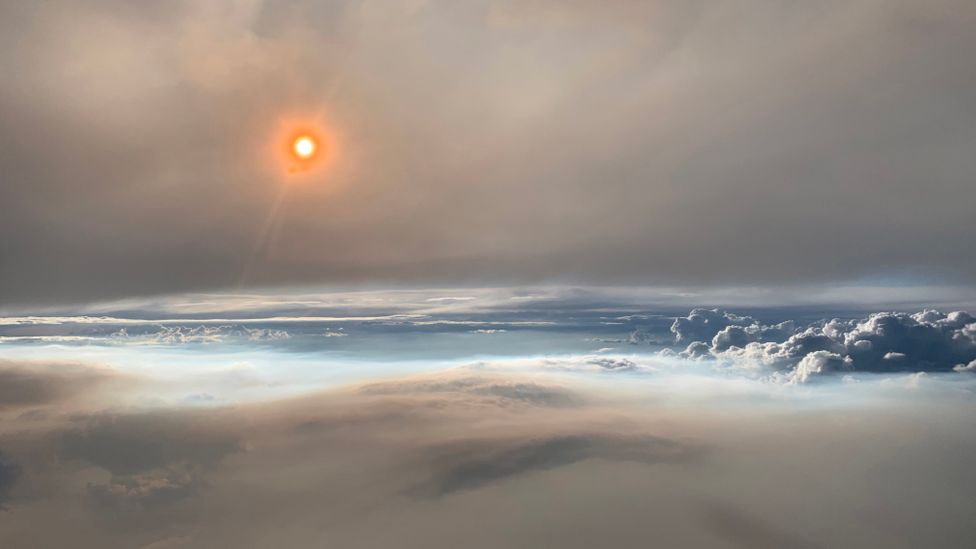
PyroCbs transport smoke up high into the atmosphere, as shown by this rare image taken from an aircraft that flew through a PyroCb (Credit: David Peterson/Nasa Earth Observatory)
Back across the Atlantic in Pedrógão Grande, as early evening approached, thick smoke blocked the sun and made it difficult for the villagers to see or breathe. The fire sucked air towards it, generating wind speeds of up to 117km/h (73mph) and rocking cars in a nearby municipality. Still the flames charged on, now devouring 4,460 hectares (17sq miles) of forest an hour.
But the most dramatic, dangerous moment was still to come.
At about 8pm, the dark cloud of smoke – now 13km (8 miles) high – "collapsed" through its plume, sending cold air whooshing down to the base of the fire and fanning it with oxygen. According to the investigation later commissioned by the Portuguese government, villagers described the moment the air touched down as "a sudden 'bomb' of fire spreading tongues of flames and sparks in all directions".
The rapid outward surge of the fire resulted in most of the 64 deaths that occurred in the Pedrógão Grande incident, with the majority of victims overwhelmed or overtaken by flames as they tried to escape on the roads.
Portugal would suffer three more pyroCbs that June, and a further one in October, with total wildfire fatalities reaching more than 120 for the year.
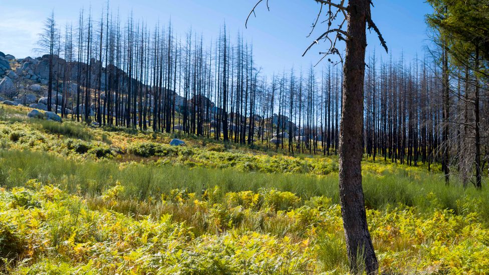
The wildfires of 2017 in Portugal damaged swathes of the country, and the scars left behind take a long time to heal (Credit: Getty Images)
Marc Castellnou, a Spanish wildfire investigator, was called to Portugal after the first incident to help the government investigation unearth what had happened. A trained firefighter and fire engineer, Castellnou had roved between large wildfires in Europe, the Americas, Africa and Australia since the mid-1990s, trying to understand their behaviour better. He knew that wildfires were a common and normal event in Portugal – but not like this. It did, however, look worryingly familiar.
Five months earlier, Castellnou had headed up an EU team to investigate huge wildfires in Chile's Maule municipality, about 270km (168 miles) south of Santiago. Like in Portugal, the fires in Maule went through a sudden huge acceleration, says Castellnou. "By 25 January, the fire had been burning for 10 days, but that night it suddenly grew four times larger, fanning out 110,000 hectares [425 sq miles] in one night," he says.
Afterwards, Castellnou walked the path of the fire and flew a helicopter over to look for clues.
He found a distinct pattern – "streets" of trees that had all fallen in one direction, and also trees that showed no sign of flames having reached their tops, as they normally would in an intense fire. This meant the fire had stayed largely on the ground but had also created its own air circulation system – a wind strong enough to batter down trees.
"We realised that this was not classical wildfire behaviour and the energy had to come from somewhere else," says Castellnou. "It meant the fire was getting cold air, and the only way to get that was vertically. Somehow the fire was sucking in air from the higher part of the atmosphere and that must have been battering down flames to the ground. Those flames could then burn a lot more fully, creating more energy that helped lift the smoke plume higher to touch cold air.
"Every time the plume doubled its height, the wind multiplied by six on the surface. That meant that the wind could [rapidly] go from 5-10km/h (3-6mph) to 150km/h (93mph)," he says.
In addition to these ferocious winds, Maule had experienced the same "collapsing" pyroCb cloud that Portuguese villages had described. But in the Maule fire, the unusual weather wasn't confined to Chile. Smoke from the fires travelled 1,000km (620 miles) north to just off the coast to the Juan Fernández Islands, where it caused humidity to fall from 90% to 20% and temperatures to lower by 3-4C, says Castellnou.
"Fires [like this] are not behaving according to the weather that we can predict in our models – they do not depend on topography, meteorology or fuels anymore," says Castellnou. "Instead, the fire behaves according to the weather it is creating, which means we can also no longer predict the weather when such a fire is occurring. It's what we call wildfire dynamic behaviour."
In the three years after these fires in Chile and Portugal, Castellnou was called to investigate pyroCbs and other extreme wildfire behaviours in South Africa, Bolivia, Australia – and three times in California. Currently, he has 83 open investigations into this type of wildfire behaviour involving meteorological phenomena. In the 1990s, he had two or three.
Understanding pyroCbs better is now his main preoccupation. "Analysis is crucial. If we can predict then we can protect… but otherwise we can lose everything."
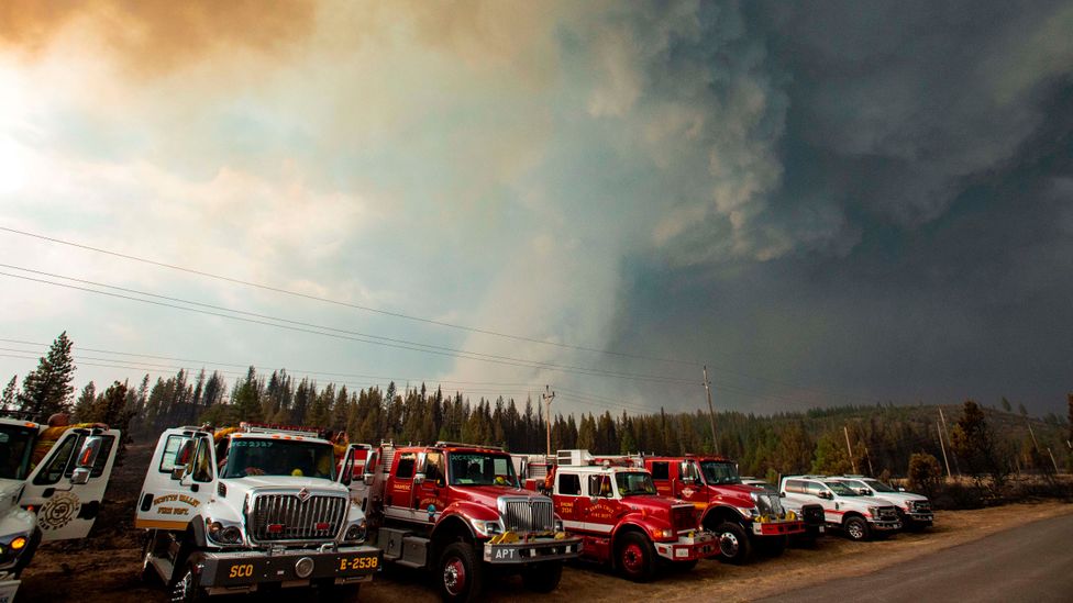
If scientists are better able to understand and predict the behaviour of pyroCbs, it could offer a better chance of containing or preventing the fires (Credit: Getty Images)
Castellnou warns that as the climate warms, and land management practices change, northern Europe could soon see this type of extreme wildfire meteorological events. He is now putting his hopes in Mark Finney at the Missoula Fire Sciences Laboratory in Montana, the only laboratory in the US devoted to experimental work on wildfires.
Working with a team of meteorologists and fire behaviour experts from around the world, including Castellnou, Finney has been building a model to more accurately predict how extreme wildfires behave meteorologically. But it's a huge challenge, he explains, as fires respond to the smallest changes at the particulate level.
"We've been going back to basics in the lab to understand things and essentially decompose the fire into its pieces, in the hope that we can understand these better independently and then put them back together in a very simple model," says Finney.
At the most basic level though, every fire changes the airflow and weather around it, even a candle, he says. The flame heats the air, causing it to expand and rise, and colder air to be sucked in to replace it.
"As you get bigger and bigger fires, they involve a taller and taller volume, and larger and larger area of the atmosphere. And when these fires get big enough, there are lots of different atmospheric feedbacks," says Finney.
One of these is to create clouds. The moisture from combustion of the fuels rises until it reaches cold air, cooling and condensing to create puffy (and harmless) white cumulus clouds. But if the fire is very intense, the heat and energy push the moisture higher and higher, until the water turns to ice up in the stratosphere, between 10-50km (6-31 miles) high, spanning the region where the ozone layer sits.
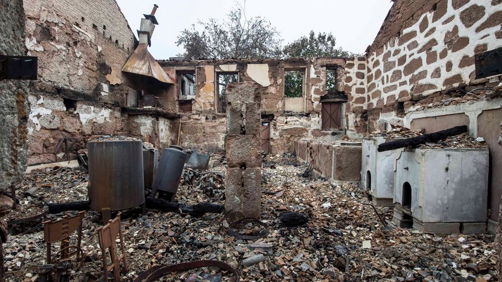
More than 60 people died in Portugal's 2017 wildfires, many of them because of the unpredictable behaviour of the PyroCb (Credit: Getty Images)
Every time the moisture changes phase – from gas to water and then ice – it releases more energy, pushing the cloud higher still and creating a positive feedback.
"At some point, it rises high enough that it runs out of energy to continue upwards," says Finney. "You end up with a lot of the particulates from the smoke, which become a nucleus for condensation. And whether it's liquid droplets or solid ice, it starts to aggregate around those nuclei, which become bigger droplets, whether frozen or liquid."
Once they become too big to be suspended in the air, they start to fall. The water goes through the phase changes in the other direction, from ice to water to gas, each time taking up more energy.
"And so it begins to flow faster and faster – and that's what leads to these downdrafts that crash down into the fire and start splattering it everywhere," says Finney. "It's the reversal of the process, it's all due to water. If you didn't have water in the plume, none of this would happen."
This may be one reason why the most recent pyroCbs have been in countries with a coastline, Castellnou believes. Portugal has an Atlantic coastline, California and Chile the Pacific, South Africa the Indian and Atlantic Oceans. Australia is of course surrounded entirely by ocean, and many (though not all) of its worst fires in 2020 were near the coasts.
The strong downdrafts also create "spotting", says Finney, where burning material is lofted off, sometimes travelling many kilometres before falling to start new fires.
PyroCbs can also start new fires through lightning, he says. "With lightning, a stroke comes from the cloud and is met with one coming from the ground. For some reason, fire-generated thunderstorms tend to have more positive return strokes than negative ones – and the positive strokes are the ones that tend to light fires," says Finney.
A further contributor – or at least not a negative feedback that could help quell a fire – is the fact that unlike most thunderstorms, pyroCbs don't tend to produce rain, since particulates in the air result in small water droplets which then evaporate before reaching the ground.
Finney's aim now is to build a model that will help predict some of these behaviours faster than real time, so that land managers and fire chiefs can act quickly when a large fire breaks out.
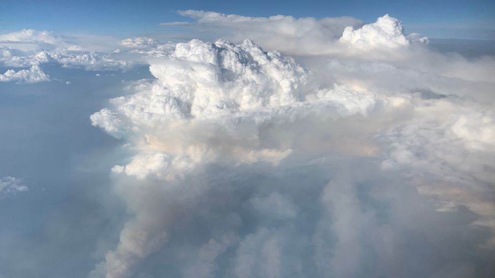
PyroCbs can send soot and water high into the stratosphere, where they linger for longer than they do at lower altitudes (Credit: David Peterson/Nasa Earth Observatory)
Extreme wildfires also have the potential to affect the climate, at least regionally, says Canadian climatologist Mike Flannigan, at the University of Alberta. Flannigan has been warning that climate change is causing more extreme wildfires for 20 years now – through drying out fuels, extending the fire season and possibly the creation of more lightning.
But less is known about wildfire contributions to climatic changes, says Flannigan. "There's lots of checks and balances in our climate system, and some of the things that fire brings cause warming and some cause cooling," he says. Some say the cooling processes outweigh the warming, while some say the reverse is true. "But it's got many moving parts, and that's why it's still hasn't been completely resolved."
Burning fuels obviously releases a lot of greenhouse gases, says Flannigan, which contribute to warming, particularly if carbon-rich peat is involved. But other mechanisms then become less clear. The soot, or black carbon, created in the fire is one of the unknown factors.
"Black carbon is very effective at warming the atmosphere, either directly [by absorbing] sunlight or by falling on snow and ice, [since] black surfaces absorb solar radiation and white surfaces reflect it," says Flannigan. "But on the other hand, smoke blocks solar radiation and can cover a large portion of the globe, causing regional cooling."
This happens when pyroCbs inject material into the stratosphere, which is normally a very stable part of the atmosphere, therefore allowing particles to stay there a longer time. The more smoke in the stratosphere, the more severe the cooling.
For example, one study found that the smoke from the Australian fires at the beginning of 2020 blocked more solar radiation than any previously documented wildfire, to the same extent as a moderate volcanic eruption, says Flannigan.
Cooling could last "from a month to a year, and from a continent to a hemisphere. These are all possibilities," says Flannigan. With climate change causing more extreme wildfires, could he see a future of planetary cooling?
"If you'd asked me that a couple years ago, I would have said probably not. Now, I'd say, yes, my mind's changed."
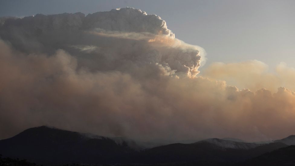
A cluster of pyroCbs occurred in Australia in 2019-20 on a scale not seen before (Credit: Getty Images)
Back in Washington DC, Fromm also observed the stratospheric smoke over Australia in 2020 using satellites, and helped detect another first for fire meteorology.
A "blob" of smoke stretching 1,000km (620 miles) gradually made its way around the Earth as an egg-like shape. It was created by a plume of smoke that was so hot it was generating its own atmospheric circulation, says Fromm. He suspects this was created by one to three PyroCbs, although he says scientists are still not sure.
"The blob started to circulate in an anti-cyclonic motion, and while it was rotating it was also moving through the atmosphere and up in altitude, and it was able to be tracked around the world," says Fromm. "We don't have a theory yet [about the impact], but we are speculating that it could actually alter the chemistry of the stratosphere."
PyroCbs have always occurred, says Fromm, and the science is still out on whether the number of them is increasing. "[But since Portugal in 2017] we have seen, not trends, but events that we've never seen before or in locations we've never seen a pyroCb before. With the Australian fires of 2019-20, we saw a cluster of pyroCbs that was more dramatic in terms of the size, number, and intensity than we're aware of happening previously, at least in the satellite era."
It's one of the many to-be-explored aspects of fire meteorology, says Fromm, but the key area of research now has to be to link these meteorological phenomena and behaviours with what is happening on the ground, before they get more extreme.
--
Join one million Future fans by liking us on Facebook, or follow us on Twitter or Instagram.
If you liked this story, sign up for the weekly bbc.com features newsletter, called "The Essential List". A handpicked selection of stories from BBC Future, Culture, Worklife, and Travel, delivered to your inbox every Friday.
"world" - Google News
May 14, 2021 at 06:15AM
https://ift.tt/3w3I5vJ
The most intense firestorms in the world - BBC News
"world" - Google News
https://ift.tt/3d80zBJ
https://ift.tt/2WkdbyX
Bagikan Berita Ini


0 Response to "The most intense firestorms in the world - BBC News"
Post a Comment